
The Unofficial White Clay & Middle Run Trail Map
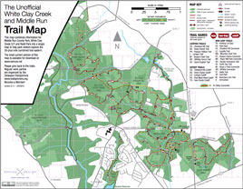
When I'm not pushing a mouse around, you can often find me riding my mountain bike in Middle Run and White Clay Creek State Park. There's over 30 miles of pristine single track in the trail system, which is downright amazing given its close proximity to the urbanized I-95 corridor.
Historically, the official park maps had trouble keeping up with the pace of trail changes, and earlier state maps didn't include the county and city owned sections of the park in adequate detail. To address this, I developed my own map of the property to help riders, hikers and runners explore the whole trail system, and made it freely downloadable from my site. As of 2013 though, I'm delighted to see that the official state park map has been greatly updated and improved, so use whichever you find easier to read (or both!).
Many maps use topographic lines to denote terrain, but non-cartographers may find my simple system of yellow arrows to indicate steep sections of trail easier to read - the arrows always point down hill, and the closer together they are, the steeper the grade. I've also included where the numerous technical trail features (such as log rides) are located so you can add some expert level spice if that sort of thing appeals to you.
To help organize all this information, my map has been created as a layered PDF document, so you can choose how much of such detail you wish to view or print. Most of the map is readable at 8.5" x 11" size, but you can easily print enlargements of sections of the map for easier viewing.
Originally, the map was donationware, but I received enough generous contributions that all I ask now for compensation is that you consider volunteering a few hours per season to help with trail maintenance - there are few things as satisfying as using a trail that you helped build (or re-build).
Enlarging sections of the map
To print enlargements of portions of the map, use the magnifying glass tool to enlarge and crop the map to the view you wish to use. Select "print", and in the print dialog box click "Current View", then under "Page Scaling" select "Fit to Printable Area". That will print the view you currently have shown at a size which will fill the paper size of your printer. Thanks to Rod and Ray for figuring this out.
Using layers in the PDF file
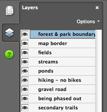
There's a lot of detail on this map you may not care about, so I've given you the ability to "turn off" things that you don't want to see. Don't want to see hiking-only trails or steepness indicators? Just hide those layers. You will need a current version of the free Adobe Acrobat viewer to use this feature.
In Acrobat, click on the "Layers" icon on the left side of the screen. You will see a listing similar to the one shown to the right. I've grouped all the elements of this map into categories which can be hidden or shown by clicking or unclicking the little eyeball in this menu. Once you only see the information you care about, press print, and you have your own customized map.
Copyright Information
This trail map is licensed under a Creative Commons Attribution-Noncommercial-Share Alike 3.0 United States License. That means you are free to make and distribute copies for non-commercial use. You are also free to build onto this project as long as the work you produce is released with this same license and you list me as a source in your work. More on this license can be found by clicking the Creative Commons badge.
